Saturday, November 15, 2014

Ojai 11/8

Sorry, too lazy to write the flight up. YouTube will tell most of the story.


The struggle to get atop Whiteledge


The plan was to land at the beach in Santa Barbara. But after struggling mightily to get above Whiteledge the thought turned to any ole beach. Got to the west end of what is known as the Powerline ridge in good shape, but after my experience in Ojai the thought was that continuing on would be a struggle, especially when I couldn't see anyone ahead of me, and with radio issues I couldn't hear either. Opted to fly out. I headed for the beach at Santa Claus lane but it was too crowded to land so I turned tail for an open field.

Wednesday, September 17, 2014

Pine 9/14


My LZs for my last two flights have been within 10 miles of each other. The only difference is that the second flight started 85 miles away. I didn’t do a write-up of my previous flight because there wasn’t much to write about. After 2 hours of bobbing up and down in front of Garlock I threw in the towel and landed right below launch. Sunday’s flight was a tad better.


We’ve had a heat wave here in Southern California over the last few days and the flying conditions have been just as toasty – everywhere. A few records have fallen. 

It’s not often that you see the tops on the front range match those in the desert. Because of that I was looking to fly either Kagel or Crestline, for no other reason than to defend my Marshall/Crestline out and return record. However, my Topa buddies had no interest in dealing with the LA traffic and were heading to Pine, and my Crestline mates were either in Santa Cruz, AZ or talking about doing an out and return out into the desert.  Since the heights were the same for the desert and the front range it made more sense to me to fly along the San Gabriels, considering the fact that the LA Basin floor is 3,000 ft. lower. I’m sure I could have convinced them to see it my way, but when the late Saturday night forecast didn’t quite match what I was seeing earlier, I opted for the safer call and joined the Topa crew at Pine.

Let me backtrack a bit here. As I mention, conditions looked good everywhere, and that included the Topatopa range in Ojai. It looked like it would be good enough to go OTB into the desert, a flight that only has been accomplished on a few occasions; once by yours truly. Unfortunately, you need a permit to fly Ojai and it’s hunting season; there was not one left to be had. However, the PGers have a hike-up launch known as the Nuthouse. Three intrepid souls opted to brave the 107 degree heat and go there, including Tom Truax who would go on to fly 111 miles, breaking the site record.


Although the forecast looked great the tops weren’t expected to be terribly high. Somewhere in the 12-13k range. Also, the winds at Pine had a bit more south than what you would like for a flight out into the desert. One of the reasons the PGs opted for Ojai instead. One thing that I didn’t see in the forecast was a call for mid to high level clouds. There was a slug of it right above launch when we arrived. There also a few lennys mixed in for good measure.  Our optimism took a bit of a hit to say the least. But, despite the high cloud cover, cumis began forming above launch just after 11:00. Not too long after that pilots began throwing off.  There were 6 in total, two in each crew. Tony Deleo was gracious enough to drive for TQ and me.

Launch

Despite the great forecast, no one was screaming to cloudbase. John Hesch and I had the same idea to search more out front, but that ended up not working any better than what was happening above the ridge. Eventually, though, everyone got up and out. Whereas the other pilots opted to go straight over the back I decided to give Reyes a try, with the idea of staying on the front side of Pine to perhaps Decision Point before going OTB. At Reyes I made a mistake that almost cost me the flight. Not getting very high on my first climb out, I decided to take what I had and head for the Chute rather than stick around for a better thermal or continue east to Haddock. I did this despite that fact there were no clouds above the Chute, compared to everywhere else (probably because of the south wind). Sure enough, I didn’t find anything above the Chute and had to bail off low toward Dry Canyon.


Reyes

There’s a nice green valley between the Chute and the ridgeline just south the Dry Canyon. I didn’t realize, though, that the landable areas of the valley sit up on a plateau. The original idea was to work the ridge to as low as I needed to go before bailing out to land. The plateau gave me little room to spare. Down below 5k I had little choice but to give up the ridge and head back to the valley. Luckily, I blundered into something right above a ranch that got me back to 9k. Plenty high to be back in the ball game but not high enough to make the jump to Lockwood, especially in a south wind. TQ had already made the jump at that point.


Climbing out of a hole

It took a while, but I eventually found something to take me into Lockwood. TQ had reported earlier that he had found something above Boy Scout road. It was still there. I was soon close to my highest point of the day making my way to Frazier, albeit along a course line a little further north than what I would have liked given the wind direction.  


On my way to Frazier

But a little skip on the east side of Lockwood gave me enough altitude to get above Frazier comfortably. Up in front of me, though, a small fire had broken out on the NE side of the mountain. I had the altitude to fly over the air traffic dealing with the fire, but I ended up leaving Frazier lower than what I had hoped in order to clear the area has fast as I could. 


Heading out into the desert

I ended up crossing the 5 with just over 9k. My glide was on the wrong side of the cloud street, but I didn’t want to give up my precious altitude fudging more south. I had my sights set on a little foothill peak sitting in the sun right behind the cement plant, and at that point it looked like I had just enough altitude to make it. Somewhere on my glide I passed TQ, although I never saw him. He would end up landing nearby.


The Antelope Valley

I did reach the peak, but it was only good for enough altitude to continue on. Despite the clouds forming above the Tehachapis the range is a bit shallow in this area; I didn’t feel comfortable diving back to them low so I took a more southerly angle. After a series of skips, I lucked into the best thermal of the day, having the pleasure of sharing it with a redtail hawk. The lift would have taken me to cloudbase, but still being a bit wary, I opted to dive out well short of it. Still, I was close to 12k which was plenty high to step back to the ridgeline.

By this point I was the only hang glider pilot flying in the Antelope Valley. TQ had landed just north of Neenatch, and two of the other pilots landed near the 5, while the other two opted to fly north, with one flying 45 miles into the Central Valley. I was the only hang glider on the Tehachipis, but up in front of me was Tom Truax on his paraglider. He indeed made the connection into the desert from Ojai. Although I never saw him I think I passed him around the 60 mile mark, right about the time that my motion sickness kicked in. 

If you’ve read this blog before you know the routine: once I get sick I have about a 20 minute window before the second bout kicks in; if I can get on the ground before that, I’m pretty much OK. But if I have a second bout then I’m a mess for at least 2 hours after that even though I’m on the ground. So the idea is to fly as far as I can in that 20 minute window. I’m not sure how high I got in thermal when I first got sick, but I do know that I reported on the radio that I was at 7100 ft at 71 miles out. One more climb and I’d have enough altitude for my 100 miler. Soon after the radio report I hit some lift. I told myself that I was going to stay with it as long as I could despite feeling the way that I did. Unfortunately, I kept on falling out of it, and frankly, I just didn’t have the mental fortitude to stay with it. Soon after that I was on the ground.


Distance: 85.5 Miles
Duration: 3:45 hours
Max Altitude: 11,948 ft.

Monday, June 9, 2014

Pine Mountain 6/8

Nice rewarding flight from Pine yesterday despite not making goal. With an east wind we were hoping for an out and return to perhaps the cement plant near Quail Lake in the Antelope Valley, but ended up turning around at the airport on the east side of Lockwood Valley.


Just TQ an old flying friend and I were up there yesterday. Both of us in need of shaking off some rust. Driving up to launch we were a bit concerned about the wind direction as there was a pretty good north breeze all the way up to the drive up north launch. However, it was coming in nicely at the south launch when we arrived. We launched one right after the other around noon. 


Launch

It took a little while to find the ticket above the ridge line, but once there things opened up. 
Soon after I was making my way against an 8mph headwind to the Chute from about 13k. Being a bit lower Todd opted to fudge back toward launch in search of a better climb.

Climbing out with TQ behind launch

The Chute was bouyant but I seemed to lose everything I tried to turn in before completing my 360s. But I had plenty of altitude to play with so I just kept on plugging up wind along the ridge line. At about the same time that TQ announced on the radio that a cumi was forming over the ridge my vario started screaming...and didn't stop until I was just north of 14k. 


East bound from the Chute at 14k

From the east end of the Chute I worked a seam between Guillermo and Grade Valley. Once near Guilermo I angled toward it. But like the west end of the Chute the air above it was buoyant but I was unable to find something to core. Rather than stopping to search I just kept plugging forward along the foothills just south of Lockwood. The problem was the lower I got the stronger the headwind as the east was funneling through the gap between Frazier and Alamo Mountain. Below 9k just short of Frazier, I was flying against a 15mph headwind. Staying along the same line didn't seem very prudent so opted to veer north into Lockwood. 


East end of Lockwood Valley

Of course when your in the middle of the valley you just hope you might flounder into something. I never did until saw a crow start to turn circles near the airport. I headed in his direction and was rewarded with the strongest (and smoothest) thermal I've been in in long time. And then just like that it was gone. Here I was thinking that I'd get another chance at Frazier, but instead I was running downwind in the other direction back in flounder mode. I was down to about 6300 ft before picking up some scraps above Boy Scout Road. At about the same time TQ was reporting that he just gotten to Guillermo with 12k. To the west of us running north to south from the middle of Dry Canyon to the middle of the Chute a cloud street had set up along the East/West convergence line. 


Convergence line out in the distance


I just needed to get up at the end of Boy Scout and we both could B-line it to the street and then just bridge it out to Ojai. And get up I did. Once I drifted over the foothills on the west end of Lockwood everything opened up. Soon I was back to 14k flying down wind to the cloud street. TQ took a slightly different line that didn't work quite as well, but he had no problem making it to the convergence line.


To make my flight more of a triangle I opted to head to the cloud that was farthest to the north. It was about halfway up Dry Canyon. I found something nearby that got me close to base and then after that I headed due south along the convergence line. Again the air was buoyant but I never really found something to stop for. I turned some half ass circles above the Chute below a cloud, but at 12,500 ft I already had plenty altitude to make it out to Ojai. And that's what I did. As did TQ not much longer after me.

Distance: 47.5 Miles
Max Altitude: 14,350
Duration: 3 Hours


Wednesday, January 15, 2014

Santa Barbara 1/5

You can grow old waiting for the perfect day. Especially when that day has to fall on a weekend. Since this is January this is Santa Barbara season for me. Sure, you can't beat cloudbase at 17, 000 ft. over some god-forsaken place in the summer, but flying down range in Santa Barbara will always be where it is at for me. There is nothing like getting in close to the terrain and putting the glider on its ear while you watch the ground fall away. And if I have to say so myself, it is a type of flying that I'm pretty good at. But the problem with Santa Barbara is its proximity to the coast. It can be soarable throughout the year, but it is at its best during post-frontal days when the temperature gradient between the ocean and land is fairly neutral. Unfortunately, last year was the driest year ever recorded. And so far this year has been just a series of Santa Ana days. But, if Santa Barbara is at its finest during  post-frontal days, the second best conditions are during Santa Ana winds. The NE winds are generally blocked by the orientation of the mountain range. But because the general flow is off-shore the marine air is kept at bay. The problem with Santa Ana days is that the XC potential is limited. The strong off-shore stuff usually kicks in between the 30-40 mile mark.

Ever since I decided to come back after my deployment flight I've been looking for one of those perfect days. A day that would really get my juices flowing again. Up to this point I've had four flights; none of which would qualify. But like I said, you can grow old waiting for the perfect day. Sunday the forecast called for Santa Ana conditions, the wife and kids would be on their way to Palo Alto, and an old friend that had been away from the sport would be making an appearance. I decided that it would at least be a good day to shake off some rust.

I met Tom Truax and Todd Quayle at Tom's house in Carpenteria. Since we weren't flying open distance the day took on a more social tone. Tom's wife Pam and TQ's friend Robin decided to join us and act as drivers. Later we would have a nice late lunch and reminisce about the old Topa Flyer days.

The forecast was calling for a better lapse rate above 3k, so we decided to head up to the higher EJ Bowl rather than the normal Eliminator (Skyport) launch. Despite being more exposed to north winds it was 
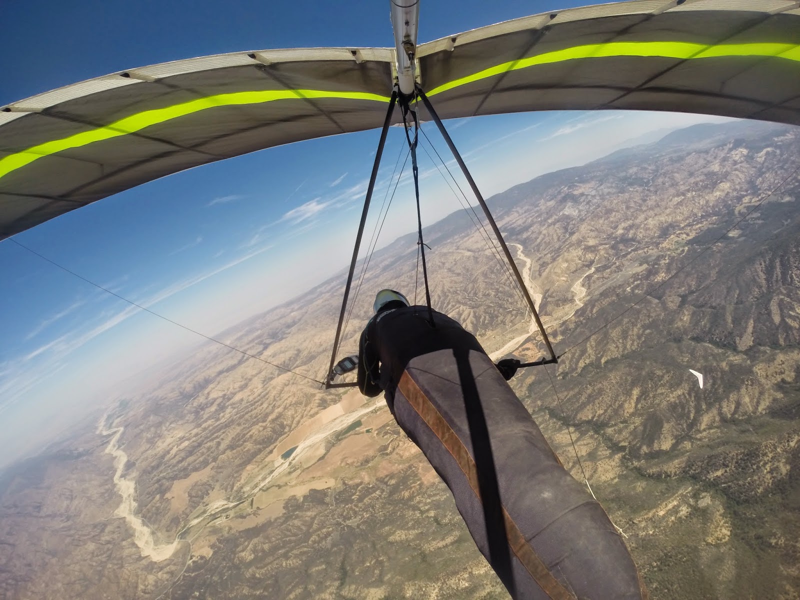
blowing up nicely when we arrived sometime around 11:00. The HG launch is off a turnoff in the road, whereas the PGs take off from a knob just above it on the range. TQ and I were dropped off as Tom was driven up to the hike in point for the PG launch. Later Pam would report that there must have been thirty PG pilots waiting their turn to take off.


About half-way through set up the PGs starting taking off with various forms of success. The first pilot off would end up flushing. But, soon after that pilots began sticking just above the spine to the right of take off. Save for one or two pilots, however, none stayed long. One by one they had to head out to the RR where they could be seen yo-yoing above and below the peak. One pilot that managed to hang on was Tom. He was still out front when I launched sometime before noon.

I have probably taken off from this launch a dozen or so times over the years and I don’t believe I have ever climbed out above it. Sunday was no exception. I made a half-ass attempt right below where Tom was, but like most of the PGs I soon found myself limping out to the RR. It should be noted here that I was still well above the Eliminator and so I was nowhere near in danger of landing at that point.

With the number of PGs reported to be at launch, I was worried about death gaggles in front of the RR. I’m not sure where they all went, but I only had to share my rather nice thermal with 3 or 4 of them as I climbed out above the peak. And at no point did I have to go wing tip to wing tip with any of them. But just to be on the safe side as soon as I had the altitude to head west I took it, with the idea of using the VOR as a turn point.


Since the RR worked so well, I just assumed it was going to be a paint-by-the-numbers day: Cathedral, West Bowl, No Name, VOR and then back again. Only, Cathedral didn’t work and I soon found myself flailing away below Tunnel Tit, which sits below the RR. Not finding anything to latch on to I had to fall off even further to the Holy Hills. While this was all happening, Tom transmitted on the radio that he was climbing through 5k over La Cumbre Peak, about twice as high as I was at that point.

But this is what is so great about flying the mountains: you usually get more than one chance to stay in the ball game. Even if I didn’t get up at the Holy Hills, there were still a couple of more option further out front. But as it turned out I didn’t need them. The Holy Hills were breathing rather nicely and I soon found myself climbing out with my old friend TQ. It has been a long time since I a shared a thermal with TQ; it made the climb extra sweet. Having said that, I’m not sure you could say that we were all that in tuned with each other. Because of that I left early and headed back over to the RR. TQ on the other hand decided to head east to the Thermal Factory.


My first go at the RR didn’t work and so I had to limp back to the Holy Hills for a re-boost.  This time I got a bit higher and soon after that I was climbing out over the RR, higher than the very first time just after launch. The goal was still an out and return to the VOR. I had the altitude now to make a play for La Cumbre Peak. When I arrived Tom was still playing in the air there. But where he was above the peak I was a tad below…and struggling. Soon after that I found myself above Cathedral again. This time I was bit higher, but still not able to dial into anything. But rather than limp back toward the east I decided to take what I had and head west to West Bowl.

I don’t know if it was just rust or the conditions, but other than at the RR and the Holy Hills I had a hard time coring the thermals. West Bowl was no exception. But after about 20 minutes of trying I finally got high enough to continue my trek west to No Name. There I came in below John Greynald on an Atos working is way back from the VOR. Robert Millington had made the tag a bit earlier; the last time that I saw him he was making his way back from the Alternator.


No Name was good for a skip to get over to the VOR comfortably where I shared a thermal with a PG that had used it as a take off spot. Tom had already made the turnaround before I arrived. As far as I could tell no other PGs flew west of La Cumbre.


I didn’t manage to get very high at the VOR but it was enough to head back. I think I left with 3k. I came in a bit low at No Name, but I ended up finding one of the better thermals of the day. Soon I was back over at West Bowl. It seemed like the day was opening up a bit, but I couldn’t find anything worth stopping for. Rather than fish around I decided to take what I had and eke over to Cathedral. Luckily, I found the best lift of the day. Good enough to get Tom to leave his thermal directly above Cathedral and head in my direction. Soon after that, both of us were on our way back to the RR. On the way over I declared that I was going to tag the Thermal Factory and then head out to the beach.


I didn’t notice it so much in the mountains, but on my glide to the beach I ran into a significant east wind. It really was a struggle to fly straight. Even though I left above the Thermal Factory there was a point there where I wasn’t sure I’d make it. But as it turned out the lower level stuff was out of the SW and I ended up needing to burn off altitude near the 101 in order not to breach the restricted airspace. Tom, however, would come up short and was forced to land on the railroad tracks. TQ was already at the beach when I arrived, opting to stay closer to launch during his flight. Overall a nice 2 hour jaunt.